back
next
ARCHES NATIONAL PARK PHOTOS.
PURCHASE GREAT MEMORIES OF YOUR VISIT TO ARCHES NATIONAL PARK- FOR HOME OR OFFICE!
Arches National Park
Arches National Park is about 237 miles southeast of Salt Lake City using Utah State Highway 6 to Highway 191. The park is about four miles south of Moab.
KEY SITES TO VISIT ARE DESCRIBED BELOW.
Sites to view, photograph and hike are:
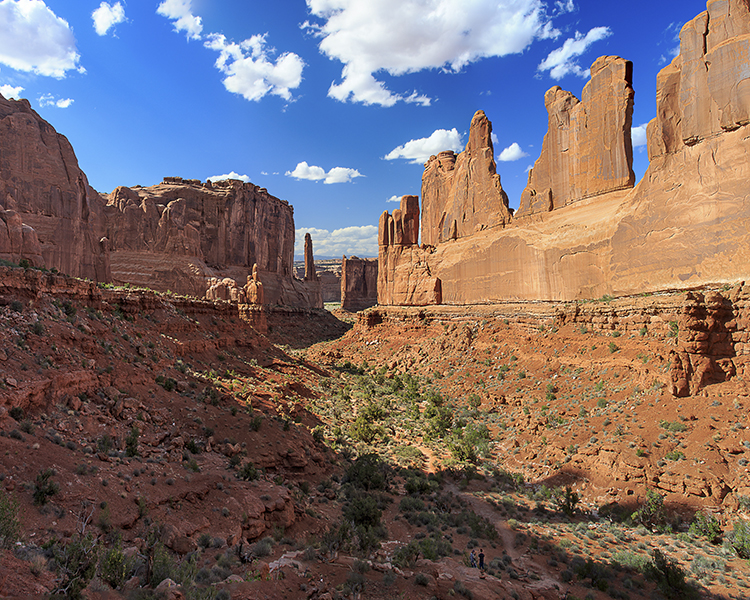
Park Avenue Viewpoint and Trail head, La Sal Mountains and Sand Flats, and Delicate Arch. All are best viewed during late afternoon when these photographs were taken. Note, I did not take sunrise or sunset shots on this photo shoot, chosing to do astrophotography instead.
Three Gossips, Courthouse, Turret Arch and Windows section are best viewed during the morning. I personally found 8:30am-10:30am in early May prime lighting to illuminate these sites as well as Double Arch. Fiery Furnace can be viewed in the morning on the road leading to Delicate Arch- a panoramic view displayed in this gallery. It is best viewed from its viewpoint late afternoon when the La Sal Mountains are lit up and the furnace glows red. I chose instead to go down Highway 128 to capture Fisher Tower, La Sal Mountains and two men rowing a boat down the Colorado. Nice of them to stop by and provide scale in the foreground. The Windows sections can be viewed both in the early morning and late afternoon depending what you want to capture.
Balanced Rock was captured late afternoon and night along with stars. The Colorado River on Route 128 at night is a hidden gem. The stars are numerous and the bluffs on the south side of Arches National Park are illuminated by moon light. I was lucky, the moon was one third illuminated which provided lighting for bluffs, Balanced Rock and the Colorado when I shot photographs are 11pm at night. I even captured a meteor streaking near a tower on the bluff over the river.
Art Rock outside Moab- Utah State Highway 279
This Scenic Byway provides great views of the Colorado River, ancient rock art and dinosaur tracks. This byway begins 4.1 miles (6.6 km) north of Moab, where Potash Road (U279) turns off of Highway 191. After 2.7 miles (4.3 km) Potash Road enters the deep gorge of the Colorado River. At the 4 mile (6.4 km) point, look for rock climbers on the cliffs along the section of Potash Road, locally known as Wall Street.
At 5.1 miles (8.2 km) several petroglyph panels are visible on cliffs on the right side of the highway. Marked pull-offs on the left side of the road provide parking to view these panels. An interpretive sign provides additional information. Further down the road visitors can see another petroglyph panel.
Kane Creek Blvd. Site
On the south side of the Colorado (opposite from the Byway), one can see two different sets of rock art. Moon Flower Canyon (not presented) and another 1.2 miles down the road and down the slope of the road sits a large boulder with rock art on all sides. This rock has a petroglyph known as "the birthing scene" presenting child birth - feet first. This is the most unique rock art experienced in this area. Nearby are petroglyphs of a centipede, horse and other assorted drawings.
Upper Colorado River Scenic Byway- Utah State Highway 128
This spectacular route along the Colorado River gorge begins at the Colorado River Bridge on the north end of Moab. For the first 13 miles (20.9 km) it parallels the Colorado River within a narrow section of the gorge, providing breathtaking views of the surrounding red sandstone cliffs.
At 13 miles (20.9 km) the gorge widens as the highway proceeds past Castle and Professor Valleys, which have been the shooting locations for many western films including Wagon Master and Rio Grande, along with numerous television commercials. The Moab to Monument Valley Film Commission has a museum at the lodge located at Mile Marker 14. Admission is free.
About halfway along 128 you'll see a sign to Fisher Towers. To the East you'll see a few low fins standing at the end of a vast butte. From the highway they don't look very interesting or even very photogenic. Take the road out there anyway. The magnificence of the Towers doesn't become fully apparent until you walk among them. After 24.7 miles (39.8 km) the highway passes a viewpoint for one of the grandest views in the west, the red rock spires of the Fisher Towers set against the often snow covered peaks of the La Sal Mountains.
Sego Canyon Rock Art
Sego Canyon contains rock art from three different Native American cultures and a very well preserved ghost town. The canyon is located on Interstate 70 East of Green River at exit 185. Drive north through Thompson Springs and you arrive at a "sort of" paved road. If the road turns to gravel and you arrive at the Ghost town, you have driven past the rock art. There is a pull off on the left side of the road and the parking is very poorly marked.There are pictograms (pigments applied to the surface) and petroglyphs (motifs pecked, abraded or scratched into the rock.) going back to the Barrier Canyon (2000 BC??) and Fremont (450-1250AD) periods as well as Ute drawings from about 1200 to 1800 AD. Click on the link below for more details on Arches National Park.
National Park Service-Arches National Park Information


; "Late Afternoon hike in Park Avenue")
; "The Three Gossips")
; "La Sal Mountains Glow")
; "Delicate Arch")
; "Double Arch Hikers")
; "Under the Double Arches")
; "Early Morning Windows Hike")
; "Turret Arch Hikers")
; "Late Afternoon Windows Glowing")
; "Fiery Furnace Fins and Spires Panorama")
; "Colorado River Cruise with Fisher Tower View")
; "Colorado River Rafting")
; "Balanced Rock")
; "Balanced Rock Star Show")
; "Stars and Comet Streak Above Arches National Park")
; "Cliffs and Colorado River Star Show")
; "Petroglyph Panels on Route 279")
; "Horned anthropmorphs holding spears, rope, and animals")
; "Birthing Rock Petroglyph")
; "Sego Canyon Pictogram Panel")
; "Sego Canyon Anthromorphs- 1200 AD")
; "Sego Canyon Fremont Petroglyphs~1250 AD")
; "Sego Canyon Ute Art")
; "Colorado River Sojoun")