back
next
Bandelier, Kasha-Katuwe Tent Rock, New Mexico Photos
Imagetripping sells unique framed images of Bandelier, Kasha-Katuwe Tent Rocks National Monuments in New Mexico.
Gallery 30 features Bandelier National Monument, Kasha-Katuwe Tent Rocks National Monument, Jemez Mountains, Plaza Blanca Landscape photographs.
Bandelier National Monument:
Bandelier National Monument was established in New Mexico in 1916, and features cliff dwellings, kivas, petroglyphs and wild life on 33,727 acres. The Monument shelters the remains of an ancestral Pueblo settlement. From the 12th to 16th century. Successive communities settled here, hunting and growing corn and sguash. The earliest occupants carved out cave dwellings from the volcanic rock of the towering cliffs, while later people built houses from talus (rock that has fallen from the cliffs). The Main Loop Trail leads past Tyuonyi to cave homes and the Long House, multistoried homes built into the cliff.
The Tyuoni was one to two stories high and contained about four hnudred rooms which housed about 100 people. The central plaza contained three kivas. The big Kiva was photographed and most of the Tyuoni walls are partially hidden in tall grass and flowers.
These cave rooms were dug out of the south-facing soft cliff walls. The walls were plastered with clay, and the ceilings still have soot from the fires that were used for light, heat, and cooking.
We attempted to show the park from wide sweeping panoramic views to that of the large cliffs, rock formations, individual caves, petroglyphs, wild flowers in bloom, and ancestral pueblo art.
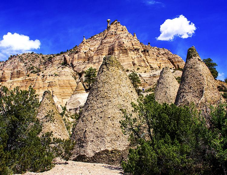
Kasha-Katuwe Tent Rocks US National Monument:
Kasha-Katuwe Tent Rocks became a US National Monument in 2001. It is located in the Pajarito Plateau in north-central New Mexico 35 miles to the southwest of Santa Fe. From Santa Fe, take the Cochiti Pueblo Exit 264 off I-25 onto NM 16. Turn right off NM 16 onto NM 22, and follow the signs to Cochiti Pueblo and the National Monument.
�Kasha-Katuwe� means �white cliffs� in the traditional Keresan language of the pueblo. The Pueblo de Cochiti has always considered this area a significant place. The complex landscape and spectacular geologic scenery of the national monument has been a focal point for visitors for centuries. Surveys have recorded many archaeological sites reflecting human occupation spanning 4,000 years. During the 14th and 15th centuries, several large ancestral pueblos were established and their descendants, the Pueblo de Cochiti, still inhabit the surrounding area. Currently, the Bureau of Land Management manages the monument in a partnership with the Pueblo de Cochiti, University of New Mexico and the Sandoval Country. Elevation of the monument ranges from 5,570 to 6,760 feet above sea level.
The cone-shaped tent rock formations are produces of volcanic eruptions occuring 6-7 million years ago and leaving pumice, ash and tuff deposits over 1000 feet thick. Over time, wind and water cut into the deposits froming canyouns, arroyos, and the tents.
In 1540, the Spanish explorer Francisco Vasquez de Coronado made mention of the Pueblo de Cochiti in their diaries. Throughout the 17th century, settlers would follow Juan de O�ate�s route along the Rio Grande Valley, bringing trade, farming and domestic animals, and claiming land grants from the Spanish Crown. In 1680, the Cochiti people joined other pueblos in a rebellion that drove the Spaniards south to El Paso, Texas. By 1870, the railroad stretched into the territory of New Mexico bringing loggers, miners and others to enjoy its rich natural resources.
Plaza Blanca:
Plaza Blanca is south of Abiquiu which is about 50 miles northwest of Santa Fe. Plaza Blanca is on the grounds of Dar-Al-Islam, which is a Muslim educational center. They have graciously opened up their grounds so visitors can enjoy this natural wonder. Towering gypsum formation and colorful Indian brush along with red rocks, dry river beds and streams make this a magical hiking location. Warning: flash flood potential, no drinking water, and home to rattle snakes.
Jemez Mountain Trail and New Mexico State Route 4 Panoramic Photographs
The Jemez Mountain Trail is one of six scenic routes in New Mexico designated as a National Scenic Byway, an honor given to only 55 routes in the nation. It begins in the village of San Ysidro, the only surviving settlement of the original seven�Pueblos de los Jemez� formed under the Spanish crown. Hwy 4 follows the course of the Jemez River to the towering mesas of the Ca�on de San Diego and Jemez Pueblo. Continue north to the spectacular crimson-colored formations known as Red Rocks. Walatowa and Pueblo of Jemez is in the heart of red rock country along State Route 4.
Jemez State Monument:
Jemez State Monument consists of the ruins of an ancient pueblo of the Jemez people known as Giusewa and the ruins of a 17th Century Spanish Mission known as San Jose de los Jemez. The mission had a unique octagonal-shaped bell tower. There is a museum and signed trail at the Monument, which is part of New Mexico State Monuments. The pueblo was first built in the AD 1500s by ancestors of the modern residents of Jemez Pueblo.
To the east on Route 4 lies Valles Caldera National Preserve, one of the largest volcanic calderas in the world. Close by is Jemez Falls. An easy mile long, round-trip hike along a trail offers views of the river as it drops 70 ft in a series of waterfalls.
Continue east to the cliff dwellings at Bandelier National Monument and end at White Rock, New Mexico. White Rock has a tremendous overlook where there is almost a 300 degree view of the Rio Grande River snaking through the White Rock Canyon and the Sangre de Cristo Mountain range.
Santuario de Chimayo, a small church in Chimayo, N.M., between Taos and Santa Fe
Santuario de Chimayo, known as the �Lourdes of America,� follows a long tradition of miraculous Catholic shrines and is perhaps one of the most visited churches in New Mexico. It is considered a venerated pilgrimage site. On Good Friday during Lent, as many as 30,000 pilgrims come on foot, walking from as far as Albuquerque to experience the site and petition for healing. It is famous for its �Holy Dirt� believed to have curative powers. The shrine receives about 300,000 visitors every year. On Good Friday during Lent, as many as 30,000 pilgrims come on foot.
Chimayo was settled by a group of Spanish families in the 1700�s. The Church was founded in 1816 by Bernardo Abeyta and other residents of the then-separate village of El Portero. It was purchased by the Spanish Colonial Arts Society in 1929 and donated to the Roman Catholic Archdiocese of Santa Fe. The church has been compared to Lourdes, and the National Park Service has called it �one of the most important Catholic pilgrimage centers in the United States.�
In 1970, it became a National Historic Landmark. Native Americans came to this place on the Rio Santa Cruz to soak their ailing bodies in the healing mineral waters long before the arrival of the Spanish. Local legend tells that in 1813, on the evening of Good Friday, Don Bernardo Abeyta had a vision that led him to discover the Crucifix de Nuestro Se�or de Esquipulas, the "Black Christ of Guatemala," buried in the bank of the river. Through a series of mysterious events, villagers believed El Se�or de Esquipulas could not be removed from the site and that Don Bernardo Abeyta was spared from death by the deity. By 1816 local families built a wood framed adobe chapel over the sacred site. Faithful pilgrims have come to the chapel ever since seeking remedies and cures from "Our Lord of Esquipulas" and the healing powers of El Posito, the sacred earth from beneath El Santuario, where the Crucifix was discovered. This gallery features images of the Sanuaro Church, Mosaic Art, Mural of the history, and bell tower.
Useful New Mexico National and State Monument websites:
Jemez Mountain Trail Information
Bandelier National Monument Web site


; "Hiking Above the Kasha-Katuwe Tent Rocks")
; "Kasha-Katuwe Tent Rocks-Hiking Trail")
; "Climbing Kasha-Ketuwe Tent Trail")
; "Kasha-Katuwe Tent Rocks-Hiking")
; "Kasha-Katuwe Tent Rocks Slot Canyon View")
; "Kasha-Katuwe Tent Rocks Slot Canyon Trail")
; "Bandelier National Monument Ancient Pueblo Cliff Caves Panoramic View")
; "Bandelier National Monument Ancient Pueblo Cliff Caves with ladders")
; "Cliff Home and Petroglyph")
; "Large Kiva")
; "Cliff Home and Ladder")
; "Long House and Petroglyph")
; "Long House and Cliff Trail")
; "Macaw Petroglyph")
; "Mural at Walatowa Jemez Pueblo Visitor Center")
; "Jemez Mt Trail-NM Rt4-Red Rock Country")
; "Jemez State Monument 17th Century Spanish Mission")
; "Jemez State Monument")
; "Jemez Pueblo Window View")
; "Jemez Falls")
; "Plaza Blanca Cliffs and Dry River Bed")
; "Plaza Blanca Window")
; "Santuario de Chimayo National Monument")
; "Santuario de Chimayo Entrance")
; "Santuario de Chimayo Mosaic")
; "Santuario de Chimayo Mural")